
Information
No Sidebar
This template supports the unlimited sidebar's widgets.For adding widgets to Portfolio sidebar Click Here

The Hydraulics Research Center (HRC) has conducted this study based on the contract agreement signed on the twenty-third of August 2017, between the client “Sudanese Thermal Power Generating Company (STPG)” and HRC, as a national pioneer institute in the field of river morphology.
The STPG intended to establish a thermal power plant with an initial capacity of 750 Mega Watts, subjects to future extensions, at Al Bagair area 42 km south of the capital, Khartoum. The proposed water intake site of the plant is located on the left bank of the Blue Nile River, near Al Bagair Village.
The main purpose of this study is to provide a technical advice to STPG and recommend the most suitable location of the water intake for Al Bagair power generating plant that is subject to minimum morphological changes. The study also prepared conceptual design of the intake, including; analysis of variation of water level, identification of soil type, and conceptual design of the pump house.
The hydrographic survey comprises land and bathymetric surveys to define river cross-section within the study area, and velocity measurements using Acoustic Doppler Current Profiler (ADCP) to derive water velocity profile in the neighborhood of the site. The land and bathymetric surveys were used to generate contour maps of the river topography in the vicinity of the pumping site. 4 Hydrological analysis has been carried out to investigate the variation of water level, and hence expected river discharge and water depth at the pumping station. This was done using data from the neighboring gauge station of Soba (26 km downstream). The analysis of the daily water level data for 48 years has shown that, the minimum water level at the proposed site is 372.05 m msl, while the maximum water level can reach 380.9 m msl, for a 100 year return period. The impact of the Ethiopian Grand Renaissance Dam (GERD) on flow regime along the Blue Nile, has been analyzed and results showed that GERD will modify the flow regime significantly by lowering the maximum water level by 2 to 3 m and increases the minimum level by around 2 m.
The long-term evaluation of the river morphology derived from satellite imageries of 1987, 1998 and 2017 showed major changes of the river course during the last three decades. This is a typical natural process in alluvial rivers. However, relatively more stable reaches were identified in the study area.
In this study, the bank and the bed soil within the vicinity of the study area is classified as Sandy Loam. This result was derived based on soil samples analysis carried out from previous HRC’s morphological studies along the Blue Nile River.
See Poster
Related Projects
-
Water Productivity
This project was one of the outcomes of the strategic partnership-setting meeting between the Minister of Irrigation and Water Resources (MoIWR) and the Food and Agricultural Organization (FAO) Sudan...
-
أثر مياه النيل على العلاقات السودانية المصرية ما بعد سد النهضة
تناولت الدراسة بشيء من التفصيل والتحليل أثر مياه النيل علي علاقات السودان ومصر ما بعد قيام سد النهضة الأثيوبي، وكان ذلك في أربع فصول يحوي كل عدة فصل محاور....
-
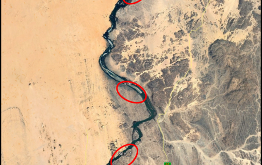
Selection of the Nile gauging site upstream High Aswan Dam
As per a request from the Permanent Joint Technical Commission for Nile Water (PJTC), The Hydraulics Research Center (HRC) conducted a study to investigate a suitable location of a...
-
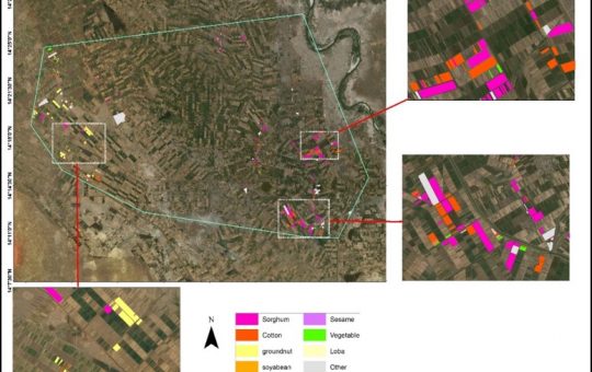
Mapping of Cropped Areas in Gezira Irrigation Scheme Using Remote Sensing and GIS techniques
Irrigation schemes in Sudan face many challenges. One of these challenges is to determine the actual cultivated area for the crops, in particular for large schemes such as Gezira...
-

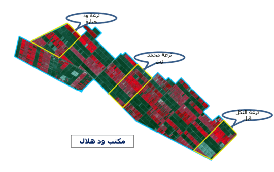
Investigation of the Drainage Problems of Sabir Branch Protective Drain in New Halfa Irrigation Scheme
This study is intended to investigate the flooding problems of Sabir Branch Protective drain, where every year floods flowing from Albutana plateau threatens New Halfa Irrigation Scheme and also...