
Information
No Sidebar
This template supports the unlimited sidebar's widgets.For adding widgets to Portfolio sidebar Click Here
It is evident that fluctuations in velocity (flow pattern) initiates either erosion or sedimentation problem, according to energy balance theorem. Therefore, investigation and mapping of flow pattern at the vicinity of water intakes is essential at all stages of establishing and commissioning a water supply pumping unit.
This study has been carried-out upon the agreement between the Hydraulics Research Center (HRC) as an specialized institute in morphological studies, and Hi-Que Company limited, as executing company of five large domestic water supply plants in Sudan; Namely: Sennar, Wad Medani, Um Magat, Soba and Shendi. The
main objective of the study is to map the flow pattern at the vicinity of Sennar and Wad Medani domestic water supply in-takes, which are now under construction.
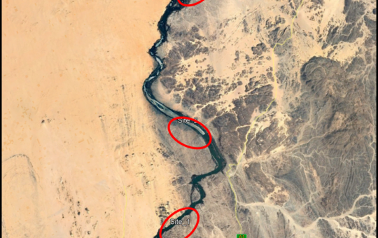
Velocity measurements were carried-out at the above mentioned locations during the period 17 – 18 September 2017. Acoustic Doppler Current Profiler (ADCP), Echo-sounder and Global Positioning System (GPS) mounted on a rubber boat, were used to facilitate the estimation of velocity (magnitude and direction).
Measurements were taken at five and eight x-sections within the vicinity of Sennar and Wad Medani pumping locations, respectively.
Velocity profiles were made covering an approximated distance of 100 meters along the coast and 100 meters inside the river.
Mapping of the estimated velocity reveals that the velocity magnitude varies from 1.6 to 2.4 m/s at Sennar with a maximum values near the pumping location (left bank), and 1.1 to 2.3 m/s at Wad Medani with a minimum values near the pumping location.
Related Projects
-
Water Productivity
This project was one of the outcomes of the strategic partnership-setting meeting between the Minister of Irrigation and Water Resources (MoIWR) and the Food and Agricultural Organization (FAO) Sudan...
-
أثر مياه النيل على العلاقات السودانية المصرية ما بعد سد النهضة
تناولت الدراسة بشيء من التفصيل والتحليل أثر مياه النيل علي علاقات السودان ومصر ما بعد قيام سد النهضة الأثيوبي، وكان ذلك في أربع فصول يحوي كل عدة فصل محاور....
-
Selection of the Nile gauging site upstream High Aswan Dam
As per a request from the Permanent Joint Technical Commission for Nile Water (PJTC), The Hydraulics Research Center (HRC) conducted a study to investigate a suitable location of a...
-
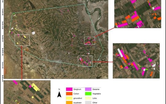
Mapping of Cropped Areas in Gezira Irrigation Scheme Using Remote Sensing and GIS techniques
Irrigation schemes in Sudan face many challenges. One of these challenges is to determine the actual cultivated area for the crops, in particular for large schemes such as Gezira...
-

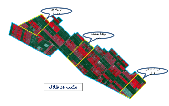
Investigation of the Drainage Problems of Sabir Branch Protective Drain in New Halfa Irrigation Scheme
This study is intended to investigate the flooding problems of Sabir Branch Protective drain, where every year floods flowing from Albutana plateau threatens New Halfa Irrigation Scheme and also...
-
Satellite Based Information and Communication Technology (ICT) for Improved Crop Production in the Gezira Scheme
Water scarcity and food security are key concerns for the growing population in the arid and semi‐arid zones. Water is becoming an increasingly scarce resource for agriculture and other...