
Information
No Sidebar
This template supports the unlimited sidebar's widgets.For adding widgets to Portfolio sidebar Click Here

1. Background on the Sediment Monitoring Program (1988 – date)
The formerly Ministry of Irrigation and Water Resources has started an intensive sediment monitoring and management program in the Gezira Agricultural Scheme in 1988. The program was sponsored under the Scheme Rehabilitation & Modernization Fund. The program has been implemented by the Hydraulic Research Station (HRS/HRC) in collaboration with the Hydraulic Research (HR Ltd) – Wallingford. Accordingly data was collected from 52 locations scattered within the scheme on a daily basis for two seasons (1988/89 and 1989/90). From the season 1990/91, the Sediment Monitoring Program was extended to cover different locations scattered along the Blue Nile in addition to the Gezira Scheme. These stations are El Deim, Wad ElAis and Sennar along the Blue Nile; they were used to help in defining the optimum filling dates of Roseires and Sennar reservoirs. In the season 1996/1997, the program was extended once again to cover the Rahad Scheme. Sediment data from other stations in the Main Nile, Dinder, Rahad and Gash River are available for some seasons.
Over more than 25 years, the program has witnessed many changes, e.g. the number of the monitoring sites in the Gezira scheme at K57 reduced to only 3 locations based on observations of long time series of sediment concentrations. Also, new monitoring sites are activated or planned to be introduced in the near future. Concerning soil mechanics laboratory performance, there is continuous efforts to provide the laboratory with new equipments and devices to enable achieving the optimum accuracy for conducted tests.
2. Achievements of the program
The Sediment Monitoring Program has established a huge database on the sediment various characteristics of the Nile River system and the irrigation schemes. In details, it contributes to:
- Quantify the sediment entering some irrigation schemes, particularly Gezira scheme, and determine its distribution.
- Establish correlation between the rate of inflow and sediment concentration within the Nile River system and the irrigation schemes.
- Define the optimum filling dates of the Blue Nile reservoirs and to avoid when unnecessary releases to the Gezira scheme in periods of sediment peaks.
Related Projects
-
Water Productivity
This project was one of the outcomes of the strategic partnership-setting meeting between the Minister of Irrigation and Water Resources (MoIWR) and the Food and Agricultural Organization (FAO) Sudan...
-
أثر مياه النيل على العلاقات السودانية المصرية ما بعد سد النهضة
تناولت الدراسة بشيء من التفصيل والتحليل أثر مياه النيل علي علاقات السودان ومصر ما بعد قيام سد النهضة الأثيوبي، وكان ذلك في أربع فصول يحوي كل عدة فصل محاور....
-
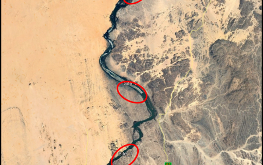
Selection of the Nile gauging site upstream High Aswan Dam
As per a request from the Permanent Joint Technical Commission for Nile Water (PJTC), The Hydraulics Research Center (HRC) conducted a study to investigate a suitable location of a...
-
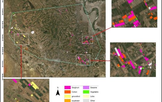
Mapping of Cropped Areas in Gezira Irrigation Scheme Using Remote Sensing and GIS techniques
Irrigation schemes in Sudan face many challenges. One of these challenges is to determine the actual cultivated area for the crops, in particular for large schemes such as Gezira...
-

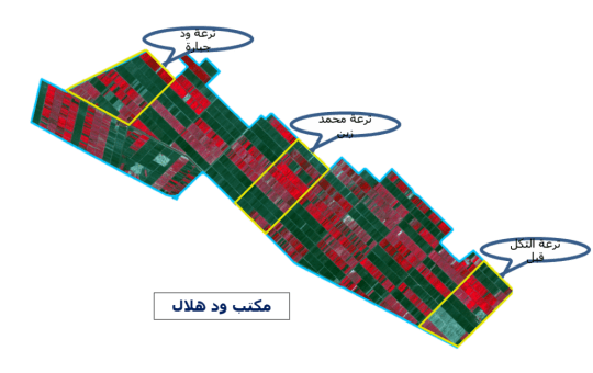
Investigation of the Drainage Problems of Sabir Branch Protective Drain in New Halfa Irrigation Scheme
This study is intended to investigate the flooding problems of Sabir Branch Protective drain, where every year floods flowing from Albutana plateau threatens New Halfa Irrigation Scheme and also...