
Information
No Sidebar
This template supports the unlimited sidebar's widgets.For adding widgets to Portfolio sidebar Click Here

Introduction:
- – Water resources management decisions are important to effectively utilize the resources.
- – The need for an early forecast is important to support decision making, for better water resources planning; e.g., to mitigate impacts of floods, drought.
- – The seasonal forecast can be up to couple of months in advance
- – It has been found that the El Nino-Southern Oscillation (ENSO) – sea surface temperature (SST) index represents the ENSO index in this study – of the eastern Pacific Ocean is one of the factors that influence the climate over the world and it is related to inter-annual variations of precipitation and stream flow in several regions of the world. (The most common region is Nino 3.4).

Methodology:
The method used in this study is based on the relation between the SST in the Pacific Ocean in region Nino 3.4 and the discharge of June, July, August, September (JJAS) of the Blue Nile River using the standardized indices for average SST in different quarters among the year with the standardized discharge indices during the flood season. The best correlation was considered for the prediction of the 2016 flood season .


data source: http://www.esrl.noaa.gov/psd/data/gridded/data.noaa.oisst.v2.html
Analysis:

Results:
The highest and the best correlation is over the quarter JJA with coefficient (R = 0.57). Using the ENSO forecast which are done by the IRI to estimate the average SST before the start of the season and using the equation resulted from the correlation between JJA SST and the discharge of JJAS provided that the discharge of the Blue Nile River for 2016 is likely to be above average discharge .

data source: http://iri.columbia.edu/our-expertise/climate/forecasts/enso/current/
Related Projects
-
Water Productivity
This project was one of the outcomes of the strategic partnership-setting meeting between the Minister of Irrigation and Water Resources (MoIWR) and the Food and Agricultural Organization (FAO) Sudan...
-
أثر مياه النيل على العلاقات السودانية المصرية ما بعد سد النهضة
تناولت الدراسة بشيء من التفصيل والتحليل أثر مياه النيل علي علاقات السودان ومصر ما بعد قيام سد النهضة الأثيوبي، وكان ذلك في أربع فصول يحوي كل عدة فصل محاور....
-
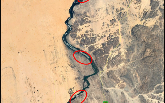
Selection of the Nile gauging site upstream High Aswan Dam
As per a request from the Permanent Joint Technical Commission for Nile Water (PJTC), The Hydraulics Research Center (HRC) conducted a study to investigate a suitable location of a...
-
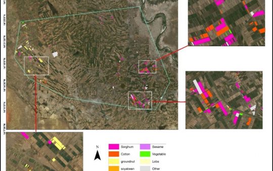
Mapping of Cropped Areas in Gezira Irrigation Scheme Using Remote Sensing and GIS techniques
Irrigation schemes in Sudan face many challenges. One of these challenges is to determine the actual cultivated area for the crops, in particular for large schemes such as Gezira...
-

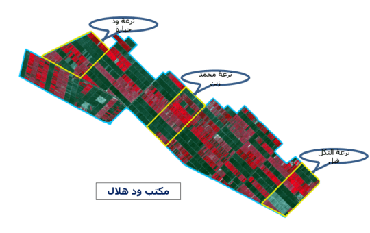
Investigation of the Drainage Problems of Sabir Branch Protective Drain in New Halfa Irrigation Scheme
This study is intended to investigate the flooding problems of Sabir Branch Protective drain, where every year floods flowing from Albutana plateau threatens New Halfa Irrigation Scheme and also...