
Information
No Sidebar
This template supports the unlimited sidebar's widgets.For adding widgets to Portfolio sidebar Click Here

Video :
Introduction :
Inland navigation is a missed potential to provide an eco-nomic and environmental friendly transport method in Su-dan and to neighboring countries. It can substitutes road transport in many parts of the country, in particular during rainy season. The Nile River, traversing Sudan from south to north, provides an important inland river transportation routesystem in particular.

Objective of the the study :
The main objective of this study is to investigate the potential of inland river transportation in Sudan.
The specific objectives for the two river reaches are :
Khartoum and Barbar line: Identify and mark the best navigation path (30 m width and 3 m depth), Identify and mark the location of obstacles in maps and tables Determine the quantities of rock and sand to be removed along the proposed path.
Khartoum and Kosti line: Identify and mark the best navigation path (30 m width and 3 m depth), Identify and mark the location of obstacles in maps and tables.

Equipment : The Hydraulics Research Center posses state of the art equipment to carry river bathometric surveys, these include: ♠ Classical survey equipment: digital leveling instruments, ♠ GPS and GPS map Sounder ♠ Differential GPS (RTK) ♠ Total Station and Echo-sounder ♠ Acoustic Doppler Current Profiler (ADCP) ♠ Survey boats and Digital Theodolites  Scope of the study : The methodology of this study is divided into to three main parts 1-The river survey provides the water depth at the giv-en cross section during the time of the survey only. However, the water depth is needed throughout the year, and for all flow conditions
  2-Hydrological was inducted for stations along river system . Example of rating curves is shown in Fig. below
  3-Here, a one dimensional model can give an accurate estimate of the water profile, and hence the water depth at all cross sections, and for different flow conditions. The water depths along the Main Nile river in March (lower season) is expected to increase in by 1.5 m after GERD.
 4- Charts and signs are akey output of this project will be detailed The maps will be prepared following standard navigation mapping in use by the Sudan Navigation Co operation, Example of navigation map is below.
Related Projects
-
Water Productivity
This project was one of the outcomes of the strategic partnership-setting meeting between the Minister of Irrigation and Water Resources (MoIWR) and the Food and Agricultural Organization (FAO) Sudan...
-
أثر مياه النيل على العلاقات السودانية المصرية ما بعد سد النهضة
تناولت الدراسة بشيء من التفصيل والتحليل أثر مياه النيل علي علاقات السودان ومصر ما بعد قيام سد النهضة الأثيوبي، وكان ذلك في أربع فصول يحوي كل عدة فصل محاور....
-
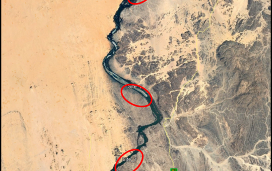
Selection of the Nile gauging site upstream High Aswan Dam
As per a request from the Permanent Joint Technical Commission for Nile Water (PJTC), The Hydraulics Research Center (HRC) conducted a study to investigate a suitable location of a...
-
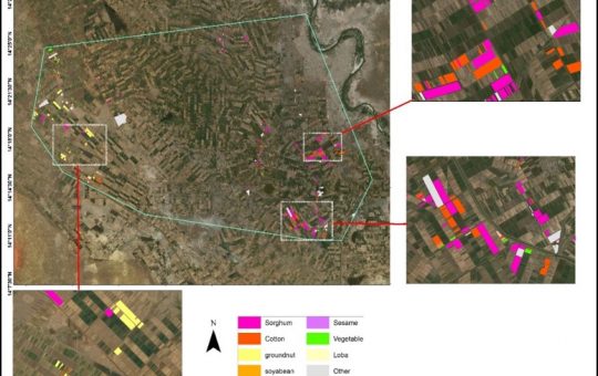
Mapping of Cropped Areas in Gezira Irrigation Scheme Using Remote Sensing and GIS techniques
Irrigation schemes in Sudan face many challenges. One of these challenges is to determine the actual cultivated area for the crops, in particular for large schemes such as Gezira...
-

Investigation of the Drainage Problems of Sabir Branch Protective Drain in New Halfa Irrigation Scheme
This study is intended to investigate the flooding problems of Sabir Branch Protective drain, where every year floods flowing from Albutana plateau threatens New Halfa Irrigation Scheme and also...